
FALKLAND ISLANDS GOVERNMENT
NOTICE TO MARINERS
No 01/2022
West Falklands
Introduction of the voluntary Falkland Islands Reporting System (FIREP)
FIREP
From the 1st June 2022, the Falkland Islands Maritime Authority will be introducing a voluntary Ship Reporting System (FIREP), to improve the Safety of Navigation of vessels within Falklands waters.
Falkland Islands Voluntary Ship Reporting System (FIREP)
- Categories of ships required to participate in the system
- Ships participating in the ship reporting system:
Vessels entering the area to the west of West Falkland, proceeding to and from anchorages or passing through the reporting area.
1.2 Vessels not required to participate in the voluntary system.
Pursuant to SOLAS 1974 Convention, as amended, the FIREP does not apply to warships, naval auxiliaries, other ships owned or operated by a Contracting Government and used, only on Government non-commercial service. However, such ships are encouraged to participate in the reporting system.
Any vessels licenced to fish within the FICZ are not required to participate in this system.
- Geographical coverage of the system
- The voluntary ship reporting system FIREP is operated by Falkland Islands Maritime Authority
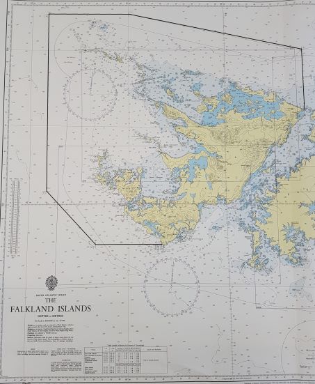
- The operational area of FIREP covers the northern and western part of the islands around West Falklands.
The area is bordered as follows:
- From white rock point (51° 24.0’S, 059° 12.0’W)
- Due North to outside 12NM (51° 00.0’S, 059° 12.0’W)
- North West to a point north of Grand Jason (50° 45.0’S, 061° 00.0’W)
- Due West to a point north west of Jason West Cay (50° 45.0’S, 061° 50.0’W)
- Due South to a point west of Weddell Island (51° 55.0’S, 061° 50.0’W)
- South East to a point west of landfall outside 12NM (52° 15.0’S, 061° 20.0’W)
- Due East to Cape Meredith (52° 15.0’S, 060° 40.0’W)
- The reference charts (Datum: World Geodetic System 1984 (WGS 84)), which include the operational area of FIREP, are:
.1 UKHO chart nos.
2512: The Falkland Islands
2513: Eagle Passage to New Islands
2514: New Islands to Pebble Island
- Format, content of reports, times and geographical positions for submitting reports, authority of whom reports should be sent and available services
- Procedures of reporting
.1 The FIREP report must be sent to the Maritime Authority by email (
.2 The type of report abbreviation must be included in the subject matter of the email as follows:
|
Type of report and abbreviation letters |
Description of report |
|
Sailing Plan (SP) |
Sent 24 hours before planned arrival into the reporting area |
|
Position Report (PR) |
On crossing the reporting line inbound to the area |
|
Deviation Report (DR) |
For deviations from the reported passage plan or for alerting to designator Q changes |
|
Final Report (FR) |
On crossing the reporting line outbound from the area |
3.2 Format
The voluntary ship report shall be drafted in accordance with the format shown in Appendix 3. The information requested from ships is derived from the Standard Reporting Format show in paragraph 2 of the Appendix to resolution A.851(20).
3.3 Content
A report from a ship to FIREP 24 hours before entering the reporting area (SP) must contain the following information:
A. Ships name and call sign
B. Date/Time of position (state time zone either UTC or LT)
C. Position (of report)
E. Course
F. Speed
G. Last Port of Call
H. ETA. Date/Time of entry in system and point of entry
K. ETD. Date/Time of exit from reporting system and point of exit
L. Intended route/passage plan
O. Maximum draft (in metres)
P. Cargo on board (inc. list of dangerous cargo with IMDG numbers)
Q. Defects/deficiencies
W. Total number of persons on board (Pax, Crew and total)
X. Remarks and additional information
A report from a ship to FIREP on entering or leaving the reporting area (PR or FR) must contain the following information:
A. Ships name and call sign
B. Date/Time of position (state time zone either UTC or LT)
C. Position (of report)
E. Course
F. Speed
X. Remarks and additional information (including changes to intended passage plan if entry report)
Note:
- On receipt of a report, operators of the FIREP will establish the ship’s position and information supplied
- The master of the ship must inform FIREP of any change to the information notified, including designator Q (DR)
3.4 Geographical position for submitting reports
.1 Ships entering the FIREP operational area shall submit a report when crossing the line from any direction or on departure from the operational area on crossing the line
.2 Further reports should be made whenever there is a change in navigational status or circumstance, particularly in relation to designator Q in the reporting format
3.5 Authority
The Authority for the FIREP is the Falkland Islands Maritime Authority, situated in Stanley, Falkland Islands. Additional details given in Appendix 2.
- Communication required for the FIREP system
4.1 The language used for communication shall be English, using IMO Standard Marine Communication Phrases, where necessary.
4.2 Details of communication and contact information are given in Appendix 2.
5. Rules and regulations in force in the area of the system
5.1 Regulations for preventing collisions at sea
The International Regulations for Preventing Collisions at Sea (COLREG) are applicable throughout the operational are of the FIREP.
6. Radio communication equipment
The FIREP system is a non-verbal voluntary reporting scheme. VHF coverage is available via “Stanley Port Control” on VHF 10 and 16, when within range.
Appendix 1
Map of the operational area of FIREP
(not to be used for navigation)
Appendix 2
Contact information FIREP and assigned VHF Channels for the Falkland Islands Maritime Authority
|
VHF Channels |
Operational use |
|
VHF Channel 10 |
Stanley Port Control – general assistance and reporting |
|
VHF Channel 16 |
Stanley Port Control – emergency assistance and reporting |
The “Stanley Port Control” operators, Harbour Master and Falkland Islands Maritime Authority are located in Stanley, Falkland Islands
All ships’ reporting for FIREP must be done via email to
H24 contact information
- The Maritime Authority are monitoring VHF Channels 10 and 16 between the hours of 0800 and 1630 LT, Monday – Sunday
- Outside of these hours VHF Channels 10 and 16 are monitored by a Central Alerting Post located in the Royal Falkland Islands Police Station in Stanley
- The Maritime Authority can be contacted
by phone +500 27233
by phone +500 54648 (24h)
by email
Address
Falkland Islands Maritime Authority
Department of Emergency Services and Island Security
The Old Design Office
Ross Road
Stanley
Falkland Islands
FIQQ 1ZZ
Appendix 3
Drafting of reports to the Falkland Islands voluntary ship reporting system (FIREP)
|
Designator |
Function |
Information required |
|
A |
Ship |
Name of the ship; call sign and if available IMO and/or MMSI number |
|
B |
Date and time of report |
A 10-digit group giving day, month, year and hours and minutes (24hr clock) in Local Time (UTC-3) (e.g. 0412211055) |
|
C |
Position |
A 5-digit group giving latitude in degrees and minutes, decimal, suffixed with S and a 6-digit group giving longitude in degrees and minutes, decimal, suffixed with W |
|
E |
True course (°) |
A 3-digit group |
|
F |
Speed in knots |
A 3-digit group |
|
G |
Port of departure |
Last port of call for the vessel given in UN LOCODE |
|
H |
Date/Time of entry |
A 10-digit group of day, month, year and hours and minutes (24hr clock) in Local Time (UTC-3) giving ETA into reporting area |
|
K |
Date/Time of exit |
A 10-digit group of day, month, year and hours and minutes (24hr clock) in Local Time (UTC-3) giving ETD from reporting area |
|
L |
Route information |
A brief description of the intended route as planned by the master, along with list of waypoints (and intended anchorage positions, if applicable) for the passage |
|
O |
Maximum draught (m) |
A 2-digit or 3-digit group giving the maximum draught of the vessel in metres (e.g. 6.1 or 10.4) |
|
P |
Cargo on board |
Nature of cargo; quantity and class of any IMO dangerous goods, if applicable |
|
Q |
Defects, deficiencies |
Details of any defects and deficiencies affecting the equipment of the ship or any other circumstances affecting normal navigation and manoeuvrability |
|
W |
Total number of persons on board |
State total number of persons on board, number of crew and number of passengers |
|
X |
Miscellaneous |
Type and estimated quantity of fuel bunkers on board when entering the reporting area Any other remarks or additional information, including changes to the intended passage plan given in the 24 hours report |
Steuart Barlow,
Deputy Harbour Master,
Falkland Islands Government
Issued on 01/06/2022